Regenerative Land Intelligence · Dear Wise Earth
Ask the land.
Draw a boundary anywhere on Earth and TERRA reads the land inside it as one living system — terrain, water, soils, climate, land cover and biodiversity, the loops that govern it, and which way they are running. In under a minute. Free, no account.
No account, no demo, no sales call. 124 readings on the wall so far, across 17 countries, every one of them public.
- Land
- Water
- The living surface
- A reading, with its loops
Read from
- Copernicus Sentinel-2
- AlphaEarth · Google DeepMind
- Sentinel-1
- Landsat
- ISRIC SoilGrids
- ESA WorldCover
- Open-Meteo
- GBIF
- OpenStreetMap
- NASA GIBS
- MERIT-Hydro
The problem
The map was beautiful. It still didn’t answer. Forty layers and no reading, or a risk score nobody can see inside, argue with, or date. So you trust it, or you hire someone and wait two weeks.
TERRA puts the verdict and its evidence on the same page. What a long-horizon owner has to live with, water, soils, habitat connectivity, climate to 2050 and the pressure around the fence, read into one scale, with every number named and dated beside it.
- “The boundaries are ten years old and nothing on the page says so.”
- Every layer is named, dated and linked on the reading: source, edition, resolution, licence.
- “It gave my land a score. It won’t tell me why, and it won’t hear a dispute.”
- Five pillars with the figures behind them, and a plain-words verdict that says what was measured, what was derived, and what was silent.
- “Forty overlays, and I still don’t know if it’s the right land.”
- A reading, not a map: Anchor, Restore, Watch or Walk, in about two minutes, with the reasons.
- “Free meant ten parcels and a card on file.”
- Reading is free. No account, no card, no country restriction. Pro buys privacy and a room of your own.
- “It stops at the border.”
- The sources cover the whole planet, so the reading does. Where a country publishes more, the reading carries that too.
- “The site report came two weeks after the visit.”
- Read first, from orbit, today. Then bring the reading to the person who walks the land.
What is inside
Six screens. Two of them are free. Four are the working instrument, and one is for the people you need to convince.
Read the land · free
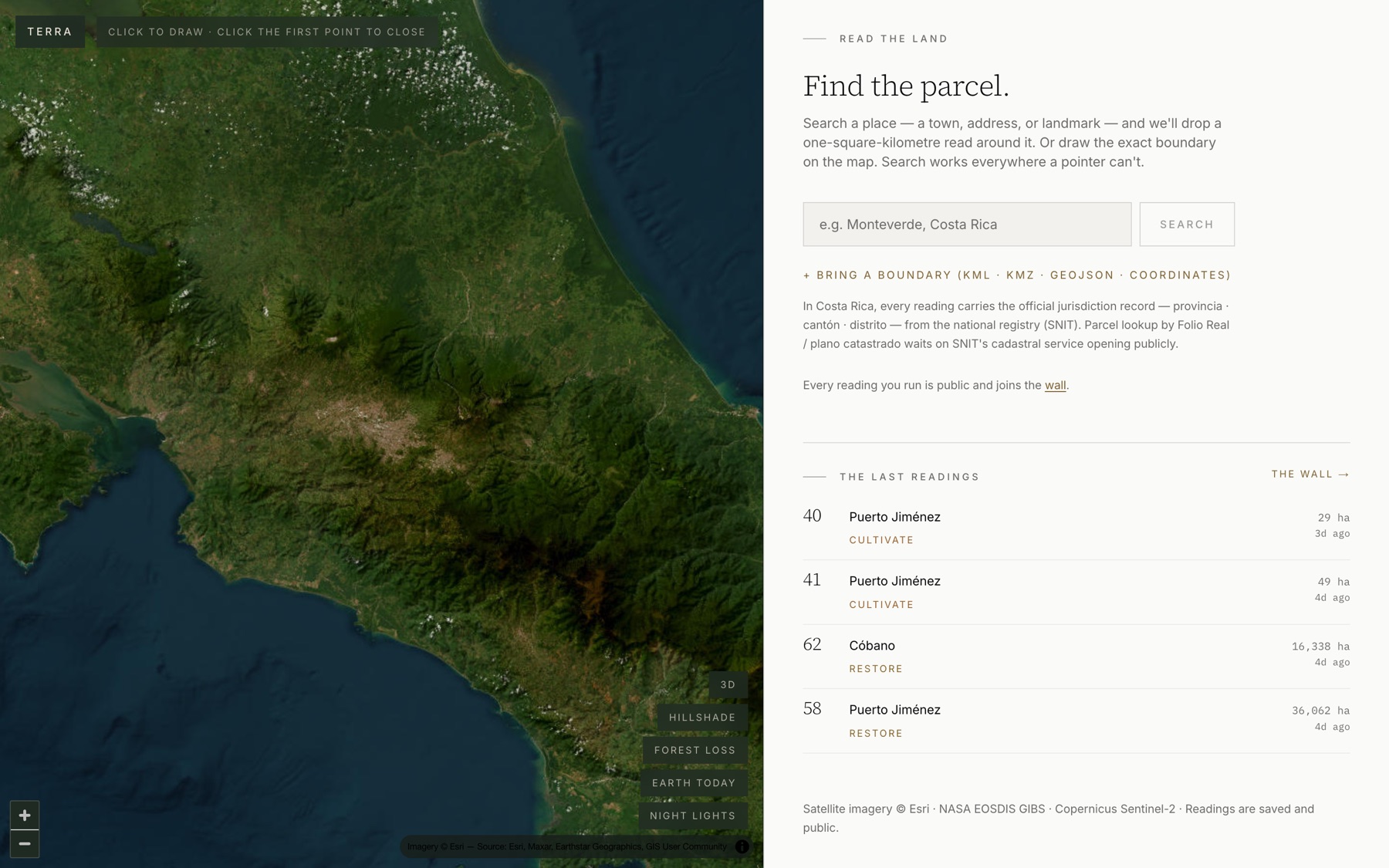
Draw the boundary. Or bring the deed.
Type a place — any place, on any continent — and TERRA reads the square kilometre around it. Draw the exact fence line if you have it, or drop in the KML your agent sent. Under a minute later you have terrain, water, soils, climate to 2050, land cover, wildlife records and human pressure, from fifteen public sources you could check yourself.
- —The same fifteen sources everywhere: they are global satellite and open-data records, not a national dataset
- —No account. A free reading is saved and public; a Pro reading stays private
- —The sources are named on the page, with the ones that fell silent
The reading · free
A number you can put in front of a partner.
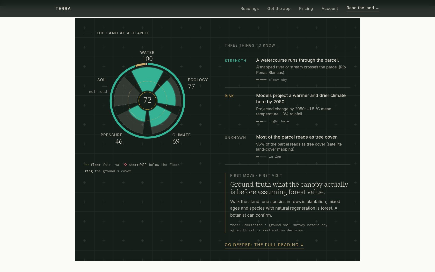
72 out of 100, Restore. That is the whole reading in four words, and each one traces to a figure on the page: the streams, the slope, the canopy, what the soil survey said and where it went quiet. Six sections take you from the land itself to what to do in the first twenty-four months, with a check to run on the ground for each.
- —It opens on the land at a glance: the five pillars as one drawing, a strength, a risk and an unknown, and the first move with its check on the ground
- —Has this ground changed character since 2017: the AlphaEarth satellite signature, the year it moved most, and the land most like it
- —Where the capital goes: corridor role, priority, and the project model that fits the ground
- —Silence is named. A missing source lowers confidence, never the score
The Data Room · with Pro, $39 a month
One link for the people you need to convince.
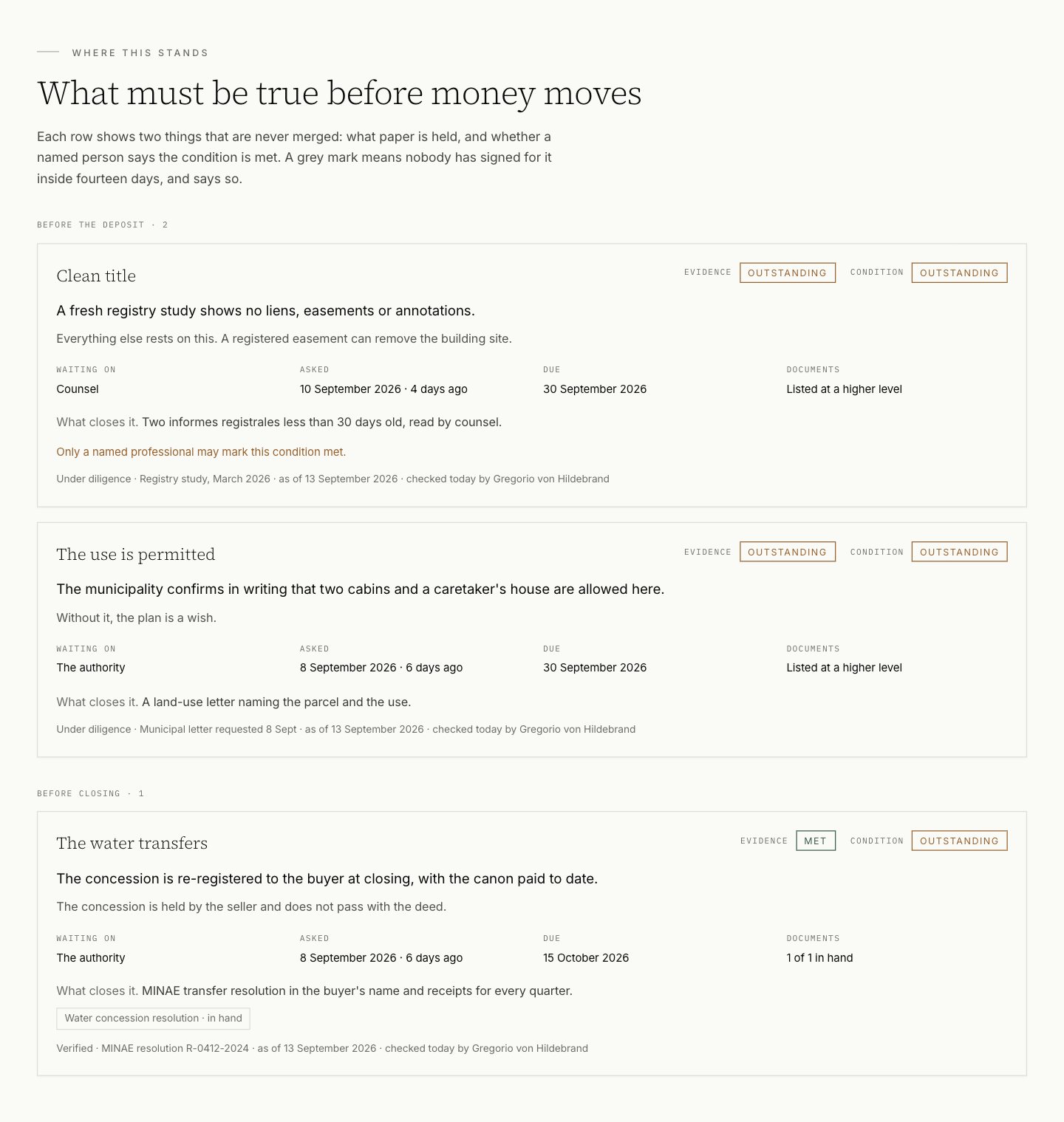
A private data room for one piece of land. You write what you know and mark how well you know it: verified, third party, the seller's word, under diligence, projection, vision. Readers come in with a passphrase, tier by tier, and you see who opened what. The conditions before money moves sit on a board where nothing shows green until you sign for it, and it goes grey again after fourteen days.
- —The land section writes itself from the parcel's TERRA reading, and the parcel is read again every season
- —What changed lands in the room's record with its direction: advanced, went against us, new question
- —Documents are an index, not a download; a blank is information
- —Up to 3 rooms, part of Pro. Print the whole record to PDF from the same rows
Compare · Pro
Three parcels. One table. Your objective on top.
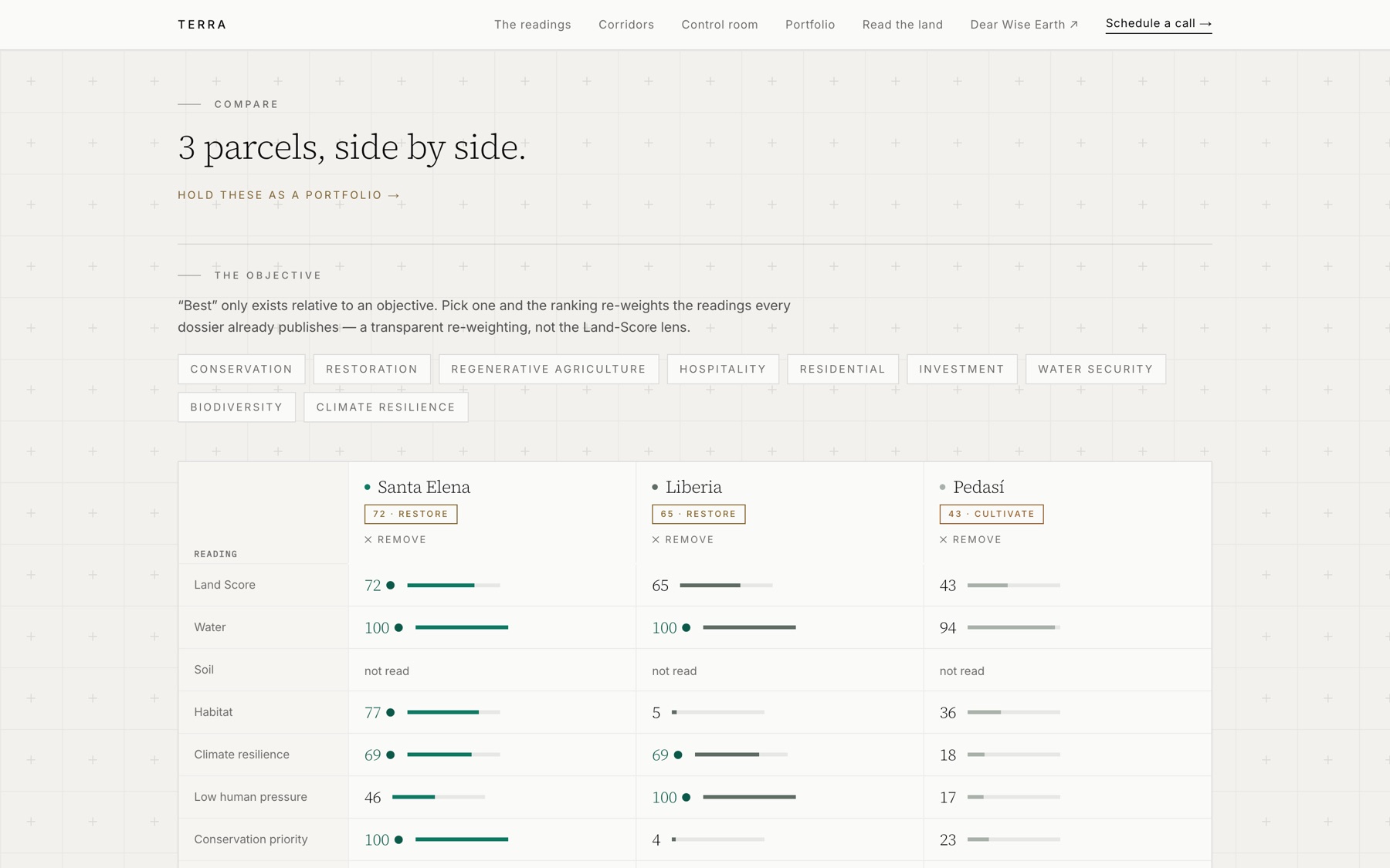
You are rarely choosing one piece of land. You are choosing between two or three. Put them side by side, pillar by pillar, then pick what you are choosing for: a lodge, a reserve, farmland, water security, nine objectives in all. The ranking re-weights in front of you and the leader changes. The weighting is printed, and the readings are the ones every dossier already shows.
- —The leader marked in every row
- —Capital tier, hospitality fit, road distance, and where each sits in its cohort
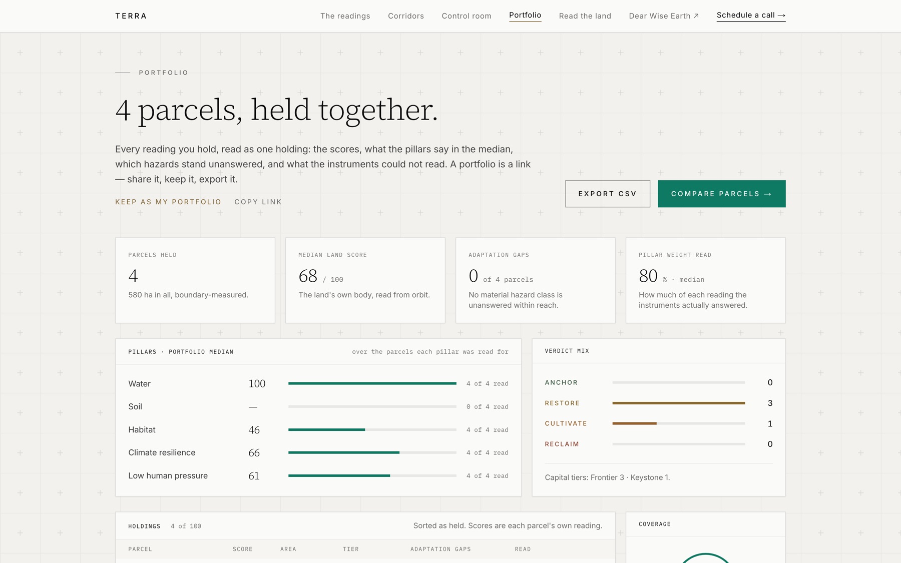
- —Hold the set as a portfolio in one click
Portfolio · Pro
Everything you hold, read as one holding.
Up to a hundred parcels on one screen: the median score, where water and soil stand across the lot, which verdicts you are heavy in, and which hazards nothing on the ground answers yet. Export the table to CSV for the fund. Send the link to the partner who wants to see it before the call.
- —A portfolio is a link. Share it, or keep it as yours
- —CSV export, one row per parcel, unread values left empty rather than zero
- —Held on your account, from the laptop to the phone in the field
Control room · Pro
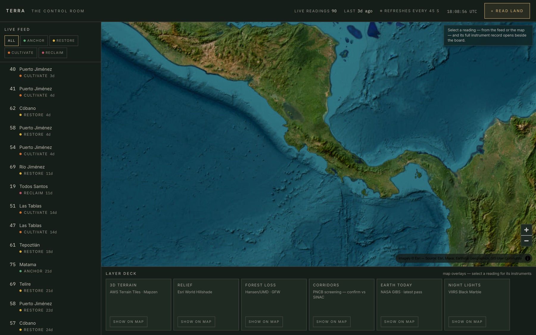
Every reading on Earth, as it lands.
A dark board built for a long evening with a shortlist. The live feed of readings from anywhere in the world, the map with 3D terrain, forest loss, the corridor network, today's satellite pass and tonight's night lights, and one parcel under the glass with its full instrument record. The analyst sits beside it and answers in plain words from the reading alone.
- —Filter the feed by verdict; a new reading arrives with a gold tick
- —The overlays on the map are the real layers, toggled live
- —Print the report, add the parcel to the table, or aim the engine at it without leaving the board
Just added
The reading, carried further: into the field, back to 2017, into a film, and to the people who act on it.
Walk the boundary
TERRA on the phone. Mark the corners with the GPS or walk the fence line, and read the parcel as walked. Field photos keep their position and heading, and readings open without signal.
Get the app →The ground since 2017
Google DeepMind's AlphaEarth satellite signature, compared year on year: the share of ground that changed character, the year it moved most, and the land most like it, on the wall and within 20 km.
See it on a reading →The land film
A reading as a short film with voice, over the land's own orbital plates and the photos taken on it. The first ten seconds are free.
Read, then film it →
Pricing
Free is the wall. Pro is a room of your own, and a room for the people you need to convince.
Every free reading is public, on the wall beside everyone else’s. Pro takes you off it: your readings stay private, and you get your own control room to hold and compare up to a hundred parcels, with no one else’s noise, and a private data room for each piece of land you are asking people to back. $39 a month, the same for everyone.
Free · no account
$0
- —Read any parcel on Earth: the score, the verdict, every finding behind it
- —Every public reading and every parcel page on the wall
- —The corridor map and Costa Rica's official jurisdiction record
- —The five standard analyst questions
TERRA Pro
$39a month·$390a year, so two months are free
- —Private readings. Every free reading joins the public wall. A Pro reading stays off it: no listing, no corpus, no link anyone else can open. Publish it later if you choose, or never.
- —Portfolio. Hold up to a hundred parcels on one screen. The median score, where water and soil stand across the lot, and the hazards nothing on the ground answers yet. Export the table to CSV.
- —Compare. Two or three parcels side by side, pillar by pillar. Pick what you are choosing for, a lodge, a reserve, farmland, water, and the ranking re-weights in front of you.
- —A control room of your own. The public board is open to everyone. Pro gives you your own: your private readings on the dark board, up to a hundred, with terrain, forest loss, the corridor network and tonight's night lights on the map, and none of anyone else's noise.
- —The analyst. Ask a parcel anything in plain words. It answers from its own reading and says when the data is silent. The five standard questions stay free for everyone.
- —Read again. Read the same boundary again a season later, or after the storm. Every reading of a parcel lines up on its page, oldest first, with the change in score between them.
- —Reports. A printable report for any reading. The maps, the narrative in full, the risks and what stands against them, and the checklist for the day you walk it.
- —Data rooms. Up to three private data rooms, one for each piece of land and the people you need to convince. Every claim marked by how well it is known, readers by passphrase.
- —Every view. Buying land, the EU deforestation rule and listings today, and the owner's, carbon and hosting views as each one opens: the same reading, explained for the question you are asking.
- —Your account. Sign in with a six-digit code sent to your email. No password to keep. The portfolio follows you from the laptop to the phone in the field.
Pro is free during the launch. No card. Sign in with your email and Pro opens. Before Pro starts charging, $39 a month, you get at least 14 days' notice by email and decide then. Nothing is charged unless you choose to pay.
Add to Pro, when you need it
VolumePriced by the file
Send a file of plots, a supply chain or a shortlist. Every plot is read and returned as one table.
Your name on the readingOn request
Readings and reports you share carry your name and logo.
Film$5 a film
A 30-second narrated film of a parcel, made from its reading.
Buying, owning, exporting, listing, restoring or hosting: the same reading, explained for your question.
Worked examples
Four readings from one engine, from strong land to a clearing frontier.
Monteverde ridge
Upper-watershed cloud forest · Costa Rica
Good bones. The rest is work.
Read the dossier →Guanacaste pasture
Recovering former pasture · Costa Rica
Worth restoring, and worth the patience.
Read the dossier →Pedasí coast
Coastal dry forest edge · Panama
A plan would change this land's answer.
Read the dossier →Amazon arc, Pará
Active deforestation frontier · Brazil
Good bones. The rest is work.
Read the dossier →One country, read deeper
The planet is the default. Costa Rica is the deep end.
Every parcel on Earth gets the same fifteen global records. A few countries publish more than that, and where they do, TERRA reads it. Costa Rica is the first: the practice that built this instrument buys and restores land there, so the national layers were worth wiring in.
- —A land-registry number from the title resolves to the registered boundary — no drawing, no KML
- —The parcel is placed in the national biological-corridor network, with a conservation-priority reading
- —The national aerial survey at 1.2 m, where the satellite pass is too coarse
- —The conservation-finance instruments that actually exist there, named in the actions
Nothing here is withheld from the rest of the world — those layers simply are not published elsewhere yet. When a country opens them, the reading gets deeper there too.
See the corridor network →AQUA · the same instrument, turned to water
Ask the water.
Draw a boundary on a lake, a reservoir, a river reach, an estuary, a bay or the open sea and AQUA reads it the way TERRA reads land: how it looks from orbit, whether it has stayed through four decades of passes, what its shore is made of, what 2050 does to it, and what stands on and beside it. One Water Score, a verdict, findings with their evidence, the first things to do with a check on the water for each, and the questions only a bottle can answer.
- Clarityturbidity and algal pigment from one clear Sentinel-2 pass, over the water pixels only
- Permanencepermanent against seasonal water in the Landsat archive since 1984, and the rain that feeds it
- Shore & lifewhat a 300 m ring of the edge is made of, the species record, protected status
- Climatethe 2050 horizon: heat, dry spells, and the water's own surface temperature
- Pressuredams and weirs, harbours, industry, outfalls, roads, towns and the people within 5 km
The readings
124 readings, and counting.
Every reading made here is public. The wall is the record: land scored for conservation and restoration value from orbit, parcel by parcel, since June.
Bolton, United States
100 ha · 44.446, -72.898
87th percentile for like land
Frontier · 43 conservation priority
The water is willing. Follow it.
Read →Antap, Indonesia
139 ha · -8.525, 115.011
44th percentile for like land
Frontier · 33 conservation priority
The water is willing. Follow it.
Read →Antap, Indonesia
296 ha · -8.523, 115.005
78th percentile for like land
Frontier · 30 conservation priority
The water is willing. Follow it.
Read →San Martín de las Pirámides, Mexico
82 ha · 19.673, -98.802
7th percentile for like land
Frontier · 17 conservation priority
The upside is here. Shape it deliberately.
Read →Puerto Jiménez, Costa Rica
29 ha · 8.394, -83.289
35th percentile for like land
Frontier · 55 conservation priority
Worth restoring, and worth the patience.
Read →Escazú, Costa Rica
100 ha · 9.926, -84.153
80th percentile for like land
Frontier · 33 conservation priority
The land remembers what it was.
Read →Questions
- What is free?
- Reading any parcel on Earth, every public reading on the wall, every parcel page, the corridor map, the phone app, the first ten seconds of a land film, and the five standard analyst questions. No account, no country restriction. Every free reading is public and stays public.
- Why pay, if reading is free?
- Because free is the wall: every reading public, beside everyone else's. Pro is a room of your own. Your readings stay private, off the wall, and you get your own control room to hold up to a hundred parcels, set them side by side under the objective you pick, export the table, and keep the board open. Thirty-nine dollars a month is less than a GIS contractor charges for the first half hour.
- What is a data room?
- A private data room for each piece of land you are asking people to back: a partner, a family, a bank, a buyer. Every claim marked by how well it is known, readers by passphrase, the conditions before money moves, and the land read again every season. Up to 3 rooms come with Pro.
- How do I pay, and how do I stop?
- You do not, for now. Pro is free during the launch: No card. Sign in with your email and Pro opens. Before Pro starts charging, $39 a month, you get at least 14 days' notice by email and decide then. Nothing is charged unless you choose to pay.
- Where does the data come from?
- Public and open sources with global coverage, named on every page: Copernicus Sentinel-2 and Sentinel-1, Landsat, ISRIC soils, Open-Meteo, ESA WorldCover, GBIF, OpenStreetMap. They cover the whole planet, which is why the reading does. Where a country publishes more — Costa Rica's SNIT land registry and PNCB corridor network, for one — the reading carries that too.
- How old is the data?
- It differs by layer, and the reading says so: each source carries its edition and resolution under Sources & method on every page, from a live satellite pass to a 2020 soil grid. When a source is silent for a parcel, the reading names it and reweights the affected pillars rather than guessing.
- Can I see why the score is what it is?
- Yes. The five pillars sit under the score with their figures, the narrative says which measurements drove the verdict, and the analyst answers questions from the reading alone. What stays private is the lens: the weights and thresholds, calibrated on land walked on the ground.
- Is this a survey?
- No. It is a first pass from orbit that says what was measured, what was derived, and what was silent. It is not a substitute for standing on the land, and it is not a listing. When the reading needs people, Dear Wise Earth works with owners in three steps, below.